No alerts

National Forecast Map Regional Weather Story
Regional Radar Precipitation Forecasts
Radar/Satellite images courtesy of Weather Underground. Images from NOAA/NWS - Click on Images for links

spacer
Updated: @ 03-Jul-2024 9:40pm - next update at 9:50pm  
Summary / Temperature Wind Rain Outlook
Night time, Dry Night time, Dry
Currently: 75.3, Max: 87.4, Min: 59.7 75.3°F
Colder 0.2°F than last hour.

Comfortable

Feels like: 77°F

24-hr difference
6.9°FWarmer 6.9°F than yesterday at this time.
  Today Yesterday
High: 87.4°F
3:47pm
85.1°F
3:15pm
Low: 59.7°F
5:38am
52.9°F
6:12am
 Calm N
0.0
Gust:
0.0 mph
0 Bft - Calm
Today: 10.4 mph 3:17pm
Gust Month: 10.0 mph July 1
Rain Today: 0.00 in
Rain Rate (/hr): 0.000 in
Rain Yesterday: 0.00 in
Storm Rain: 0.00 in
This Month: 0.00 in
Season Total: 11.95 in
2 days since last rain.
Tonight

Tonight: Scattered showers and thunderstorms before 5am, then a slight chance of showers.  Patchy fog after 2am.  Otherwise, mostly cloudy, with a low around 70. Calm wind.  Chance of precipitation is 30%. New rainfall amounts of less than a tenth of an inch, except higher amounts possible in thunderstorms.
Low: 70 °F
Humidity & Barometer Almanac Moon
Humidity: 66 % Decreased 7.0% since last hour.
Dew Point: 63.2°F Decreased 3.1°F since last hour.
Barometer: 29.986 inHg Falling 0.01  inHg/hr
Baro Trend: Steady
Sunrise: 2:00am
Sunset: 2:08pm
Moonrise: 12:29am
Moonset: 12:56pm
Waning Crescent
Waning Crescent, Moon at 27 days in cycle
4%
Illuminated
UV Index Forecast UV Index Forecast
   None
   None
 NWS Weather Forecast  - Outlook: Independence Day & Tonight
Independence
Day
Independence Day: Scattered showers and thunderstorms, then showers likely and possibly a thunderstorm after 5pm.  Partly sunny, with a high near 90. Heat index values as high as 96. Calm wind.  Chance of precipitation is 60%. New rainfall amounts between a tenth and quarter of an inch, except higher amounts possible in thunderstorms.
High: 90 °F

Slight Chance
T-storms then
Showers
Likely
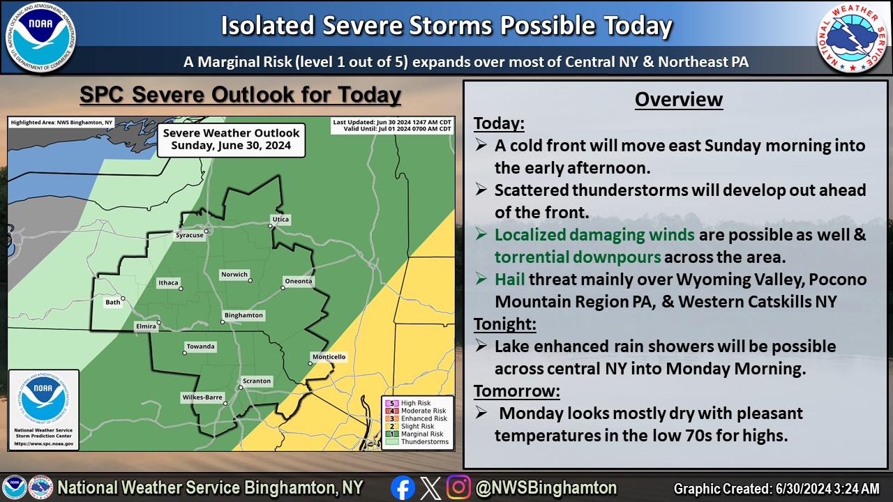
NWS forecast: Scattered showers and thunderstorms, then showers likely and possibly a thunderstorm after 5pm. Partly sunny, with a high near 90. Heat index values as high as 96. Calm wind. Chance of precipitation is 60%. New rainfall amounts between a tenth and quarter of an inch, except higher amounts possible in thunderstorms.
Davis VP+ forecast: ---
 
Tonight

Tonight: Scattered showers and thunderstorms before 5am, then a slight chance of showers.  Patchy fog after 2am.  Otherwise, mostly cloudy, with a low around 70. Calm wind.  Chance of precipitation is 30%. New rainfall amounts of less than a tenth of an inch, except higher amounts possible in thunderstorms.
Low: 70 °F

Scattered
T-storms and
Patchy Fog

NWS forecast: Scattered showers and thunderstorms before 5am, then a slight chance of showers. Patchy fog after 2am. Otherwise, mostly cloudy, with a low around 70. Calm wind. Chance of precipitation is 30%. New rainfall amounts of less than a tenth of an inch, except higher amounts possible in thunderstorms.

NWS Storm Prediction Center Map (Click to link)

SPC Activity Map

Teddybear
Cairn Terrier Rescue - Col. Potter
Cairn Rescue USA
teddybearweather.com © 2009-2019


free counters


Current weather conditions in Saratoga, Calif.
www.awekas.at
Valid XHTML 1.0 Transitional Valid CSS!

External Links


MesoWEST WXforum.net NOAA NWS
weather.gov AWEKAS APRS Wx Network/CWOP Weather Channel
USA.gov Davis Instruments PWS Weather WxUSA
Ambient Weather Virtual Weather AnythingWeather AerisWeather
WeatherforYou

OSZAR »